August 18, 2007
Taking advantage of clear air and better weather, this same path was re-done on September 3, 2007 and the signals were at least 20dB better - see details on the "Revisiting the 107 mile path" page.
This QSO was mentioned on page 80 of the March, 2008 issue of QST.
Working up to the distance...
For several months now, we have been building, testing, and refining the optical ("lighbeam") gear that has been built - not to mention getting practice in the art of setting up and operating it - all over our standard "15 mile" path (14.96 miles, or 23.85km, actually...) across the Salt Lake valley.
 |
As detailed previously (see "Our first optical contact," "More optical testing" and its related page about the comparison of coherent and noncoherent light) we'd run this "standard" test path several times with excellent results. Having weeded out most of the problems with the gear, we decided that the system performance was good enough to warrant a more severe, in-field test.
Picking a path:
Because the Salt Lake City area is bordered along the east side by some fairly high mountains - and because its geography is a rather unique combination of "Basin and Range" areas - it is relatively easy to locate fairly long line-of-sight shots. What is somewhat more difficult, however, is to find shots that are fairly long and have vehicle access at both ends of the path.
From the beginning, one site stood out as a reasonable candidate: Inspiration Point. This spot is located just north and to the west of Willard Peak, a 9783 foot (2983 meter) peak that is about 12 miles (19km) north of the city of Ogden. This site has access via a four-wheel drive dirt and gravel road and is 380 feet (120 meters) lower than Willard Peak. Fortunately, the lay of the land puts this spot west and north of Willard Peak, allowing a spectacular view to the land below in many directions - including toward the south, clearing the north-south running Wasatch range. Another important attribute of this site is that it's within a 2-3 hour drive of our homes in the Salt Lake area.
Having decided on one end of the path, we had to decide on the other end. Within 60 miles (about 100 km) or so, there were plenty of choices that offered sites that had a fairly easy drive, so we decided to narrow things down a bit. The 60 mile mark was our unofficial "minimum" distance, as we wanted to try a path that was at least four times as long as our 15 mile test shot: Having crunched numbers, we were confident that, given clear-air conditions, we would have more than enough link margin to accomplish a 2-way contact.
Initially, the southern end of the path was going to be Lake Mountain. This is a fairly low range of mountains that lies along the west edge of Utah Lake, which is west of Provo. Having driven up there a number of times on repeater-servicing trips, we were quite familiar with the road access, and its distance of about 70 miles was about the distance that we'd anticipated trying.
On a whim, I decided to look more closely at another area that I'd visited in the past: The Mt. Nebo scenic loop. This is a fairly narrow, windy, paved road that goes from the city of Payson, south of Provo, over the mountains, and intersects with Utah Highway 132 midway between Nephi (pronounced "knee-fie") and Fountain Green. Along its route, parts of it are well over 9000 feet (2744 meters) in elevation and by a quirk of geography, it, too, juts out toward the west - an important point considering that the majority of the Wasatch Range, of which Mt. Nebo is a part, is a north-south running range that would otherwise block a typical north-south path.
Utilizing various tools (such as maps and Google Earth) I located a few points along the road that appeared to have an unobstructed view toward the north. To verify the path, I used the RadioMobile program to predict, using a topographical database with 1 arc-second of resolution, what the horizontal profile of the path would be. Plugging the possible locations into the program, I determined that three of these sites were, in fact, shown to have an unobstructed view of Inspiration Point.
It just so-happens that these sites are at distances (from Inspiration Point) ranging from just over 104 miles (166.4 km) to nearly 108 miles (172.8 km) and the best of these was, according to the maps and aerial photographs, located near a radio site of some sort, at the end of a short access road. Having two other possible sites, I decided to risk that its road would be accessible to the public - but if not, one of the others would suffice. In a pinch, the original site - somewhere on Lake Mountain - could still be used.
 |
The day of the test:
On the day of the test, the weather was predicted to have scattered thunderstorms along the entire north-south length of the path with clearing in the evening. As the day wore on, it began to look promising in terms of weather, but there was another problem: The air was getting hazier by the hour for reasons unknown to us at the time. Most of the group had agreed to meet for dinner at a 4 pm at a local restaurant and by the time we'd finished at about 5, the weather in Salt Lake was looking pretty good, but the air was at least as hazy as before: Still, we decided to try it anyway, not knowing any better..
I headed south, picking up Tom, W7ETR, in Orem, roughly halfway to the Nebo site, while the other group (Ron, K7RJ, his wife, Elaine, N7BDZ and Gordon, K7HFV) headed north to Inspiration Point. While driving, we were able to maintain contact with each other through various local repeaters - at least until Ron got to Brigham City and entered a canyon to go east.
Heading south:
Meanwhile, Tom and I arrived at Payson and then began the fairly long, twisty drive up Payson Canyon. Eventually, we topped out, following the road as it wound more-or-less along the top of the ridge as it headed south and west. The first site that we arrived at was the northern-most one of the three that I'd selected, at a distance of about 104 miles. Despite the haze, it appeared that it was a suitable site, consisting of a small, paved parking lot where sightseers could look out over the wide vista. We then moved on and got to our second candidate site: This site wasn't really a site per-se, but a place at which one could park along the road and then drag the gear up the hill a short distance, getting clear of the nearby trees and out of the view (and headlights) of passing cars. Driving on, we finally arrived at the intersection of the dirt road that went to what we hoped was a suitable third site. Crossing our fingers, we drove up the road and were relieved to find that it was a rough, but reasonably good, four-wheel drive dirt road. As we climbed the last several hundred feet, we circled a hill and saw the radio site - an old (but still active) AT&T microwave telephone relay site: From this site, it also looked as though there was a clear line-of-sight path to the north - although we really couldn't see much through the haze.
Heading north:
After leaving Brigham City, Ron and company drove up the canyon to the small town of Mantua (pronounced "man-away") and began following a four wheel drive road that wound its way through the mountains, gaining elevation, and eventually ending at Inspiration Point. Here is Gordon's account of beginning of the trip:
 |
Knowing where to aim:"The road started out as just a normal gravel road, but after we got high enough to look down on Pineview reservoir, the gravel seemed to have graduated to 6-to-12-inch diameter. Thus, the ride up to Inspiration Point was even more of an adventure than anticipated. We passed at least a dozen or so folks on four-wheel ATVs, almost all headed down. As we went higher, the light sprinkles turned into solid rain, and we began to understand why the net traffic was overwhelmingly downhill. However, we spotted one Subaru following us up and closing on us. Elaine pulled over at a sharp turn in the road to let him pass, but be decided to pull over at the same spot and take a picture. It was a young fellow, probably late teens or early 20's.
"We passed 'The Saddle,' the first place with a view down toward Willard, and the location of an interpretive sign about 'The Willard Basin.' We didn't get out in the rain to read it. A few miles later we passed the trailhead for Willard Peak. A few more miles still, and we arrived at the promised 'Inspiration Point.' A small gravel road circled the point and included a small parking area just south of it. We got out, shivered a bit in the wind and rain and started searching for coats and windbreakers. A few minutes later, the fellow in the Subaru arrived, parked toward the south edge of the drivable area, spent about five minutes taking pictures and then headed back down the mountain. ([Did] he know something we [didn't]?)"
One of the difficulties in setting up any optical path is knowing precisely where to aim. While having a compass bearing to point at the far end is very helpful, nothing beats being able to relate the location of the distant end with other visible landmarks. To facilitate this, I was able to use both Google Earth and the RadioMobile program to synthesize computer-generated views of the landscape, as viewed from each location, with the distant end marked. Figures 2 and 5 are examples of the sorts of synthesized landscapes that we used for reference.
Even though the "real world" view differs somewhat from the synthesized view, it is still quite easy to pick out familiar geographical shapes and landmarks and get a "feel" as to where, exactly, the distance site is on the horizon. Even though this task was complated on this occasion by the thick haze, a sufficient number of landmarks were visible to provide a good reference, and repeated observation of the landscape as it got darker allowed one to retain a visual reference as some features - such as distant ridges - disappeared in the dark while new references - such as city lights - began to appear.
Setting up at Nebo:
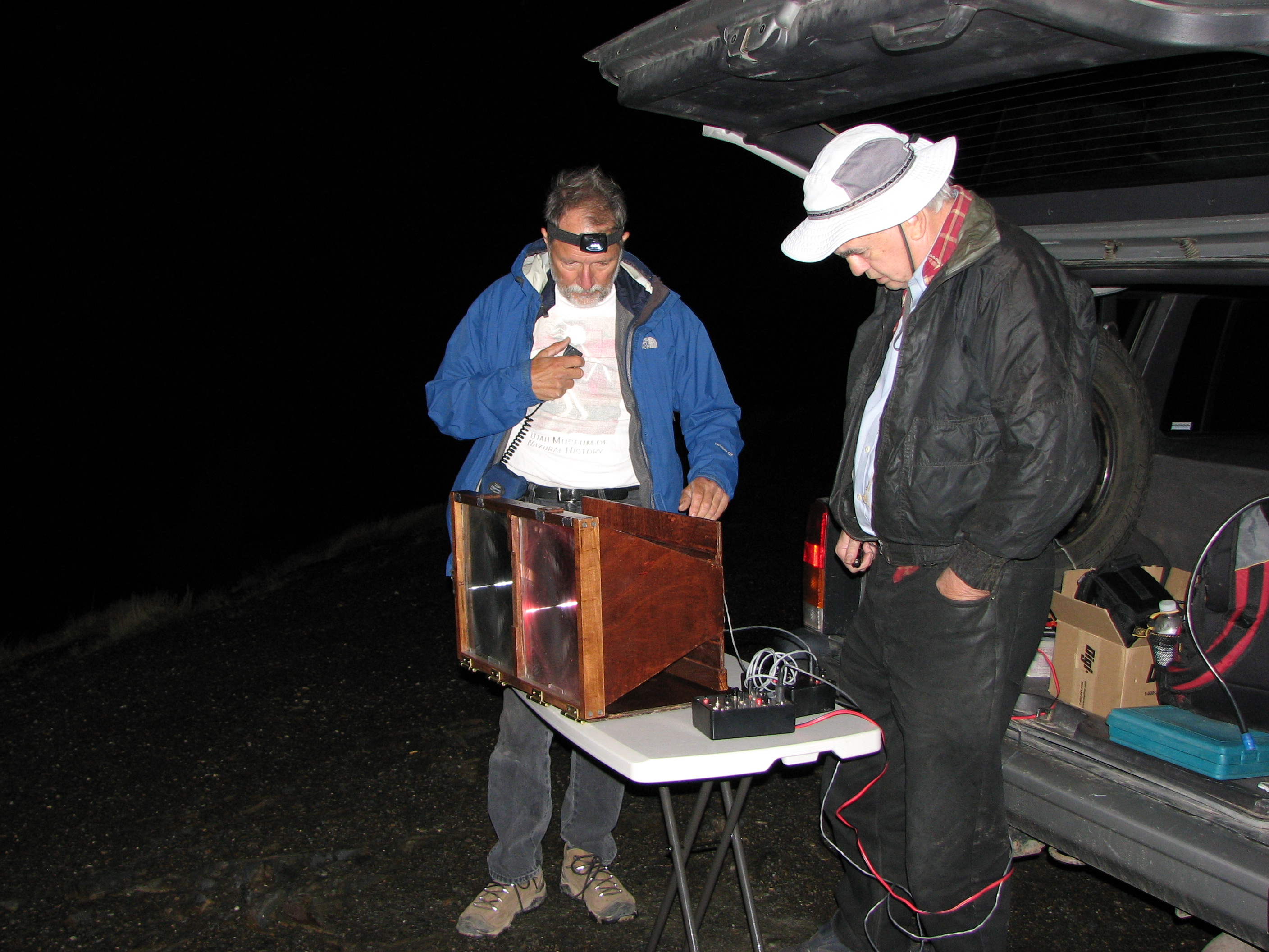
After arriving, Tom and I walked around, trying to decide where, exactly, was the best location to set up our equipment. Several areas were out of the question because of blockage by trees, but fairly near the radio site, there was a promising-looking open patch of ground. Tom was concerned about a nearby (6 mile or 10 km distant) ridge that was potentially blocking the line-of-sight path, so we decided to play it safe and follow the trail along a barbed-wire fence several hundred feet, finally parking at an open spot that improved the geometry.
Once we parked there, we noticed that the local high spot was on the other side of the fence. Not to be deterred, we carefully unlatched a short portion of the fence from its posts, laid it down far enough to be able to step over it, and ferried our gear to a spot about 50 feet away from the car, making sure that none of the roving cattle (who were, understandably, keeping a safe distance from us) even thought about trying to cross the fence where we did.
At this time it was nearly sunset and the sky was mostly clear in our area. After we had finished ferrying our gear and just started to set up, Ron called on the radio telling us that he'd just arrived and although the weather to the north wasn't as nice as it was for us, they'd started unloading their gear (which included some 10 and 24 GHz microwave radios) while we continued setting up on our end.
 |
Because it was still fairly light, all I was receiving was white noise - thermal noise from the sunlight and shot noise from the receiver itself, but as it started to get darker, I noticed that I was starting to hear lightning crashes, a sound much like what one hears on the low HF bands during summer months.
Setting up at Inspiration Point:
At about this time, things started to go bad to the north. Gordon continues:
Waiting for the weather to clear:"Ron sighted-in the spot on the distant mountains where the computer-generated pictures said the remote site should be. He then lined up rocks pointing in that direction for use later when we would no longer be able to see the mountains. We started unloading microwave gear at first, thinking we could try to make contacts while waiting for darkness.
"We had been watching lightning to the west of us and trying to identify which way the cells were moving. At first they seemed to be moving mostly to the north of us. But the rain and wind increased and the lightning started getting uncomfortably close. Elaine suggested we should get off the exposed top promptly, and Ron and I agreed. We piled back into the car and drove about a half-mile back down the road. We were able to find a hot-spot for the '76 repeater, so we could stay in communication with Clint and Tom and the Mt. Nebo end of the path."
While waiting for the weather to clear, we were joined by Chris, VK3AML via IRLP on the '76 repeater that we were using for our coordination: This seemed appropriate because it was, in large part, the work of the Australian Optical group that inspired this activity in the first place. In addition to Chris, there were a number of locals (both in Utah and in Australia) that were monitoring - some of whom were just curious as to what it was that we were doing.
 |
Meanwhile, Tom and I were completely set up, waiting for the weather to clear at the north end of the path, keeping in touch with Ron and the group. Here's more from Gordon:
(It should be noted that during transmissions made during the hailstorm, the noise from the hail was strongly competing with Ron's voice and was, no doubt, heard in Australia!)"Altogether, I believe we made three exits from the top to escape thunderstorms. It was suggested by someone at the other end that we operate in between cells. Ron responded that the time between cells was not long enough to get the equipment set up!
"At the worst time, we had lightning coming from various directions with no more than about three seconds as the longest interval between flashes. The rain turned to hail and it sounded as if a dump truck were unloading a bed full of gravel onto our roof.
"I've lost track of exactly what happened on each return to Inspiration Point, but on a couple of the returns, we noticed that we could see city lights up to about the north end of Salt Lake. At first we thought we were just seeing lights through Bountiful, but finally realized that the brightest density of lights disappeared behind a ridge and was probably Salt Lake City lights disappearing behind the Ensign Peak ridge."
During one of the brief times during which they returned to Inspiration Point, there was enough time to try a brief experiment to determine if, in fact, there was a line-of-sight path between our two locations. Elaine, who had been driving, positioned the car so that the headlights shone in our direction. Having already set up an 8" (20.3cm) reflector telescope, I pointed it in the expected direction and after a moment of searching, I spotted what appeared to be a dirty brown spot of light in the haze. To verify that I was, in fact, seeing their headlights, I announced "On - Off" on the radio while they turned the headlights on and off - and this did verify that I could see their headlights, albeit quite dimly. It was noted that the headlights were completely invisible to either the naked eye or binoculars.
While awaiting for the storms to clear, Tom and I watched the lightning activity as it drifted slowly eastwards: At times, the optical receiver - which was left on - was almost continually enunciating lightning crashes. It was interesting to note that often, a strong crash of static was heard in the receiver when there was no visible, corresponding flash of lightning in any direction. Puzzled by this, Chris offered a possible explanation: The optical receiver, also being sensitive to near infrared, was probably picking up some of the lightning flashes that had their visible light components filtered out by the distant clouds and rain.
Another interesting observation was that even though the lightning was very distant - more than 90 miles (144 km) away - that the air volume above our heads was occasionally lighting up as well. At the moment, the best explanation of this was that with the particulate haze that we were experiencing, the air high above us was in line-of-sight of the distant lightning and simply scattering the light from it. This also might be a joint explanation why we were able to "hear" the lightning on the optical receiver even when it was not visible with the naked eye.
 |
Finally - A respite:
By this time, Tom and I had stowed the microwave gear as it seemed unlikely that there would be enough time to set it up in addition to the optical testing that we were planning.
At the south end, we had the advantage of a clear, star-filled sky - and the spectacular sighting of the International Space Station docked with the Space Shuttle - not to mention the occasional bright meteor streak in the sky. After the sky had wheeled about for a few hours, Ron announced that they were returning to Inspiration point. Gordon continues:
Using the telescope, I again sighted their headlights, again verifying that there was at least some hope of being able to communicate. After a few more minutes of setting up, I began to look through the telescope while they started preliminary aiming of their optical transceiver - but it didn't take too long before a faint red dot was spotted in the distance. After a few more minutes, the light was brighter - but still somewhat dim."After ... our third return to Inspiration Point, we found the lightning further away, and the rain mostly stopped, but the wind still quite active. By now we had decided that microwave took too much setup time to be practical between storm cells and we would concentrate strictly on the optical communications trial. We vacillated a bit between setting up in the back of the Cherokee and on a portable table. We had positioned the vehicle for the Cherokee option, but, at Elaine's suggestion, ultimately used the table. This gave us better access to the equipment, but more worry about physical stability in the wind."
At this point, we decided to try the audible S-meter system: Ron modulated his transmitter with a 1 kHz tone while I put the audio interface into "S-meter" mode and after a short time of scanning, I got a weak "hit" on the S-meter and by their turning their transmitter on and off, we verified that we were, in fact, hearing the signal from the distant end. After further peaking of my receiver, I transmitted the S-meter tone over 2 meters to allow them to peak their end.
About the initial setup, Gordon writes:
It is worth mentioning that from the south end, only occasionally could we catch a faint glimpse of the distant LED with the naked eye, but most of the time it was simply not visible."At first we didn't seem to be able to hear anything on the receiver except our own transmissions. We realized, first, that we had neglected to turn on the receiver module in the transceiver box, and, second, that something was intermittent in the receiver's 9-volt battery connection.
"When those problems were corrected, we actually were able to peak the audible S-meter on the signal coming from the distant site. I found this amazing as we were unable, visually, to see a trace of the distant LED source."
Success!
After using the audible S-meter system in both directions, we decided to try to talk via voice and here is the resulting exchange. In the recording below (which is in stereo) you can, at first, hear, some chatter over the radio:
Initial exchange via the optical link:
- Initial 2-way exchange (mp3, 1:21, 960 kB)
- Initial
2-way exchange - with noise reduction
(mp3, 1:21, 960 kB - same as above, but with added noise reduction)
A few comments about the above recordings:
- It is recommended that one uses headphones to listen to these recordings.
- The LEFT channel contains the audio received at Nebo from Inspiration Point while the RIGHT channel contains audio received at Inspiration point from Nebo.
- In both cases, the transmitted audio can be heard in the receive channel from the local transmitter.
- To hear the audio transmitted from Nebo (the south end) and received from Inspiration Point (the north end) you will want to mute the right channel - or at least move the right earphone from your ear.
- To hear the audio transmitted from Inspiration Point (the north end) and received from Nebo (the south end) you will want to mute the left channel.
- Note: The crosstalk is due partly to the scattering of light in the air volume, reflecting back some of the signal. On the south end, there may have been additional loss of TX/RX isolation caused by more dust in the air, and weak reflections from the ground in front of the transceiver. In the case of the south end, things worked best in half-duplex mode, where the north-beaming LED was shut off during receive.
- Both files are identical, except that the second one has noise reduction applied in certain places on the left channel and continuously on the right channel to make it easier to hear the exchange.
- In each case, the gain was adjusted as necessary to make it more audible during playback of the recording. At the time of the QSO, we did this by turning up our volume controls.
- Upon listening to the recording from the north end, I could hear our radio chatter over the optical link even before we started talking. (That portion occurred before the beginning of the recording below.)
- Note that these recordings do not include a complete exchange of callsigns and gridsquares: We never got around to completing the exchange until about a half hour after this portion of the recording was made.
We carried on the QSO - often coordinating via 2 meters - for a bit more than half an hour before we finally were satisfied that we'd exchanged all the information that we'd needed, ending by retransmitting a portion of each of our optical receivers via 2 meters so that the Australians could hear. Over the entire time, the signals remained weak, although the lightning static had mostly subsided by the end of the contact.
Here's a bit more from Gordon:
Not having experienced any inclement weather, our trip back home was rather uneventful - mostly a matter of avoiding the occasional bit of traffic on the narrow, windy canyon road. Dropping by Orem to drop off Tom, I got home a bit after 2 AM. Ron and Elaine, after dropping off Gordon, got home closer to 3 AM."We tried exchanging grid squares to make a legitimate contact for the contest. Several times we copied Clint's 4-character grid square, but were unable to make out the last two letters. On one trial they were wiped out by feedback on our end, on another by wind noise on Clint's end.
"Clint apparently could not copy our request for a repeat of the last two characters. Finally, after more coordination on two meters, we copied the whole square ID solidly. Shortly after this event a wind gust blew practically our entire setup off the table and onto the ground. Elaine said, 'I think that's a sign from the Gods.' After some two-meter exchanges with the folks on the other end, we decided she was right and we had accomplished as much as we cared to under the conditions. We started tearing down.
"The trip back was uneventful except for some new lakes that had formed in the upper parts of the road. The whiplash quotient was somewhat less than that of the up-bound trip. Surprisingly we passed an ATV and a pickup truck on their way up the road. It was now nearly 2 A.M. We joked that it was probably the Sheriff investigating a report of a strange red light coming from Inspiration Point."
Additional details:
 |
First of all, I'd like to thank those that helped, including:
- Tom, W7ETR who was with me during the QSO and helped in the setup, but I mention on the air very much.
- Ron, K7RJ, suffering at the far end.
- Elaine, N7BDZ, Ron's long-suffering wife
- Gordon, K7HFV - also long-suffering.
And, of course, Chris, VK3AML and Mike, VK7MJ and the others in VK-land.
At the south end of the QSO:
Present: Clint, KA7OEI with Tom, W7ETR.
Location: Along the Mt. Nebo Scenic Loop Road that goes between Payson and Birdseye, Utah.
WGS84 coordinates: 39°, 51' 19.56" North, 111°, 42' 12.00" West, Altitude was 9393' (2864 meters) according to GPS.
Grid square: DM49du
At the north end of the QSO:
Present: Ron, K7RJ with his wife Elaine, N7BDZ and Gordon, K7HFV
Location: A place called "Inspiration Point" that is slightly north and west of Willard Peak, which is north of the city of North Ogden, Utah.
WGS84 coordinates: 41°, 23' 26.6" North, 111°, 59' 9.6" West. I don't have Ron's GPS reading for the altitude, but according to the USGS topographical maps, the altitude is almost exactly 9400 feet (2866 meters).
Grid square: DN41aj
Distance:
The calculated distance (as a crow flies) is 107.04 mi. (172.27km) using the RadioMobile program, version 8.0.5,
 |
Other path statistics:
- South-to-North azimuth: 352.1° (true)
- Elevation angle on South-to-North path: -0.7834°. Because our altitudes were the same, this is almost exclusively due to Earth curvature.
- North-to-South azimuth: 172.0° (true) This is slightly different than 180
degrees from the reciprocal bearing due to rounding off.
- Elevation angle on North-to-South path: -0.7668°
- Maximum difference in elevation along path: 5143 ft. (1568 meters)
Other misc. path comments:
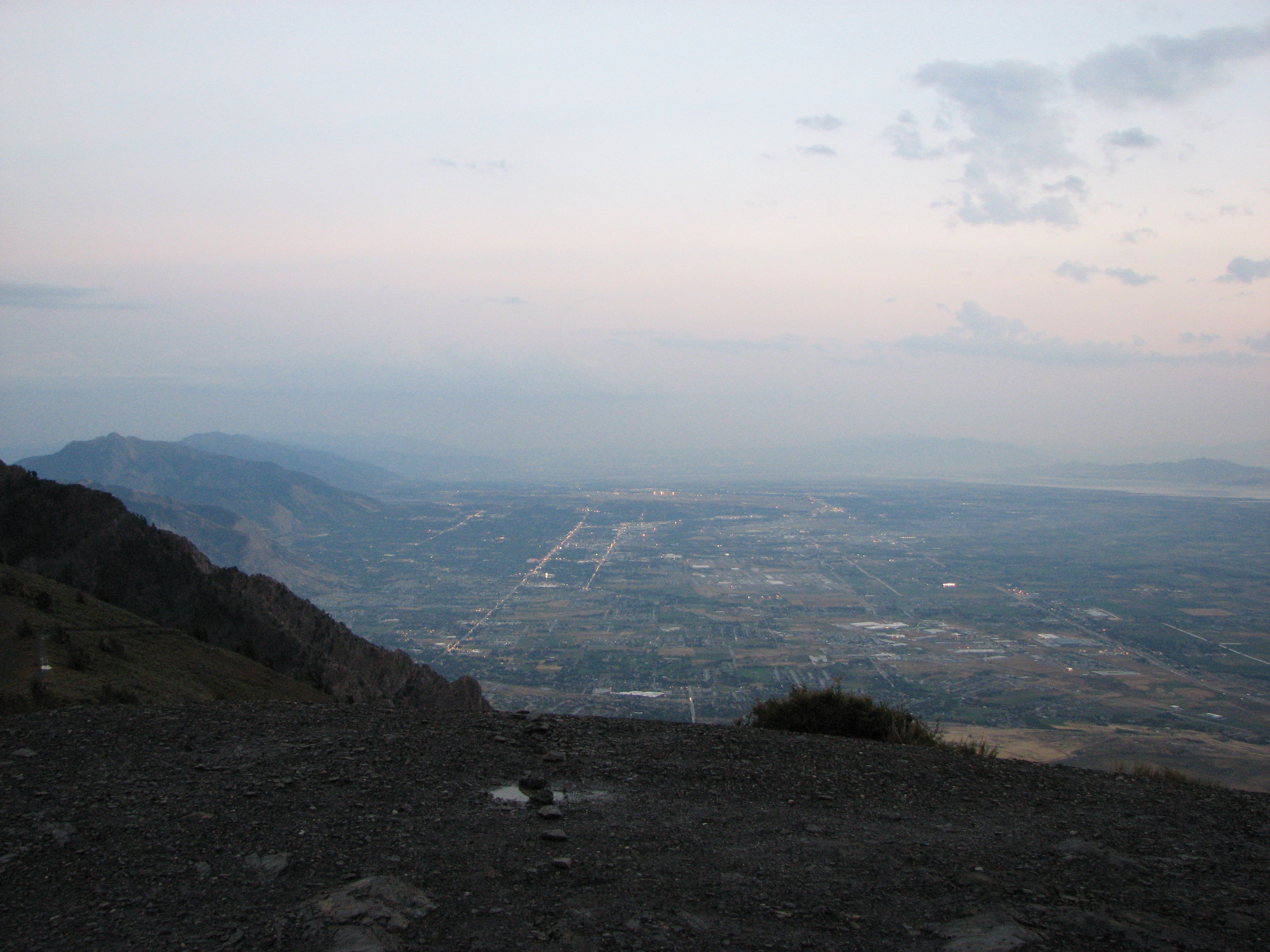
- The weather had been terrible earlier in the day, with several localized storms driven by thermal convection - a typical phenomenon during our monsoon season (July-August, mostly.) One possible reason why the northern end of the path was so-affected by weather was that the storm cells were likely powered by the warm waters of the Great Salt Lake, which kept things going even after dark.
- Unknown to us at the time, a pall of smoke was moving in from
wildfires in California and Idaho. At the time, we hoped that the
haze would be cleared by the rain, but this was true to only a very
limited extent. The following day (Sunday) was a bit hazier, but
on the day after that, Monday, visibility was extremely
poor and it is unlikely that even half the distance could be covered
under these conditions. As can be seen from the picture in Figure
3, objects only at about 2/3 the distance were nearly invisible
during the daylight.
- The above factors certainly contributed to the rather poor
optical conditions that we observed due not only to optical path
attenuation, but also from scattering of city lights along the
path: As can be seen from the map in Figure 1, between
our two locations live more than a million people
in more-or-less a straight line, parallel to and under
our optical path, resulting in a large amount of light pollution.
- The LED was amplitude modulated with a current-linear modulator
with a resting current of 1.1 amps. Details of the
modulator are here: LED_linear_modulator.html
- The transmit LED in both cases was a Red Luxeon III emitter module (Lumileds M/N: LXHL-PD09) epoxied to a heat sink.
- The optical receivers were my "version 3" design, described here: optical_rx1.html#ka7oei_rx_ver3 with both receivers using BPW34 photodiodes.
- Audio interface units, incorporating audio amplifiers, audio
recorder interface, audible S-meter, and a few other features were used
- details are here: optical_comm_audio_interface_device.html
- Both transceivers have separate and identical TX and RX lenses
mounted side-by-side.
- This enclosure is described in detail here: Optical_enclosure_first_version.html
- Lens size: Unmounted, the Fresnel Lenses are 250mm x 318mm and have a focal length of 318mm. The mounting frames vignette the lenses by about 10mm in each dimension, so the available lens area is about 240mm x 308mm. Each lens is protected by a sheet of Plexiglas and the front surface has been coated with a protective polymer to prevent scratching and moisture accumulation.
- For optimal far-field optical flux density, a glass PCX (Plano-ConveX) lens is used in front of the LED to appropriately illuminate the Fresnel, the LED-Lens distance being set empirically for best output.
Optical transceiver used on the South-to-North link:
- The enclosure is described
here: Optical_enclosure_foldable_version.html
- Lens size: Unmounted, the Fresnel lenses are 404mm x 430mm and have a focal length of 229 mm. The mounting frames vignette the lens by about 10mm in each dimension, so the available lens area is about 394mm x 420mm. Each lens is protected by a sheet of Plexiglas and the front surface has been coated with a protective polymer to prevent scratching and moisture accumulation.
- For optimal far-field optical flux density, an optical acrylic
DCX (Double-ConveX) lens was reground to an aspherical shape to provide
optimal illumination of the Fresnel. This turned out to be
necessary owing to the very short focal length of the lens that made it
difficult to efficiently illuminate the lens. After adjustment,
this LED/Lens combination produces about 25% higher far-field flux than
the other assembly, with an almost identical half-power beamwidth.
A timeline of the QSO itself:
- 0526 (2326) - First 1 kHz alignment tones heard and initial sighting-in occurred. (Actually, I think I heard a wisp of tones a few minutes earlier than this - I'll have to closely examine the recording.)
- 0537 (2337) - First time at which we were able to talk back and forth, albeit with a little bit of difficulty.
- 0558 (2358) - Final exchange of Grid squares. Ron had mistakenly been saying "DM" when it was really "DN"
- 0559 (2359) - Exchange via lightbeam over radio with Chris - last time we communicate over the lightbeam.
- 0606 (0006) - Ron shuts down. (8/19 MDT)
 |
Observations and comments from the South end, looking North:
- I can't speak for what Ron/Gordon/Elaine were seeing, but with the naked eye and through the telescope, the point in space from which we could see the Luxeon glow was bathed in an orange glow from scattering of street lighting. At one point, I pointed the receiver down a few degrees, below the distanct city lights, and on the recording, I see about a 6dB reduction in AC hum and 4-5dB reduction in "Hiss." I now wish that I'd pointed the receiver skywards to get a baseline noise floor reference.
- Only rarely was the Luxeon from Ron's end visible with the naked eye.
- Despite the much greater distance, the observed scintillation was
comparable to that noted during previous 15 mile across-the-valley
tests. Figure 9 shows a sample of the 1 kHz alignment
tone, and a 2-second image showing the worst-case scintillation
observed over about 60 seconds of tone.
- Even when no lightning - or even flashes from lighting - were visible, loud crashes could be heard via the optical receiver.
- For sighting, I used an 8" reflector telescope. With it, I could dimly see the headlights of Ron's Jeep as a muddy, brown glow, but the red Luxeon glow was quite visible. It was with the telescope that the initial sighting-in of the north-end transmitter was done, with further tweaking being done via the audible S-meter system.
Observations from the North end, looking South:
- While the weather was clear at the south end, this was not the case at the north end. Shortly after arriving on-site, Ron and company were chased off the mountain several times by fast-moving and intense thunderstorms. Fortunately, they needed go down the road only a few miles to find shelter amongst trees and surrounding ridges where they endured heavy rain, hail, thunder, and nearby lightning strikes while hunkered down in the car. Before the QSO was completed, they were forced to retreat three times before the convection-driven weather died down enough for them to set up their gear!
- Once they were able to set up, they still had to endure very high winds and some light sprinkling. At one point, a gust of wind blew the electronic gear off the table, although the wooden lens enclosure stayed put and on-point.
- Even using binoculars, no-one at the north end was ever
able to spot the glow of the north-pointing transceiver. Aiming
was done solely with feedback from the far end, plus the use of the
audible S-meter.
Taking advantage of clear air and better weather, this communications along this same path were re-done on September 3, 2007 and the signals were at least 20dB better - see details on the "Revisiting the 107 mile path" page.
Notes about the audio clips on this page:
- The audio clips on this page have been edited to remove "dead" time and irrelevant bits of dialog. This editing has been done solely to make them more "listenable" and to keep the file sizes manageable.
- In the audio clips, amplitude and gain adjustments have been made to improve listenability. At the time of the actual event, the volume control was used to similar effect for the benefit of the local listeners.
- Except as noted, no noise reduction or audio filtering has
been done, other than some lowpass filtering that was done during the
MP3 encoding process.
Return to the KA7OEI Optical communications Index page.
If you have questions or comments concerning the contents of this page, feel free to contact me using the information at this URL.
Keywords: Lightbeam communications, light beam, lightbeam, laser beam, modulated light, optical communications, through-the-air optical communications, FSO communications, Free-Space Optical communications, LED communications, laser communications, LED, laser, light-emitting diode, lens, fresnel, fresnel lens, photodiode, photomultiplier, PMT, phototransistor, laser tube, laser diode, high power LED, luxeon, cree, phlatlight, lumileds, modulator, detector